

Archive Record
Images
Metadata
Title |
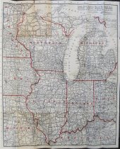
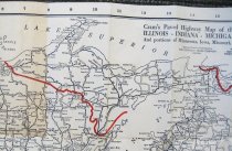
1926 Official Auto Road Map for Illinois, Indiana, Michigan and Wisconsin |
Catalog Number |
A-2019.27.11 |
Object Name |
Map |
Pub Date |
1926 |
Scope & Content |
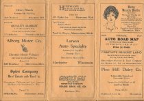
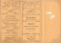
1926 Highway map showing paved, improved, and unimproved roads for the upper midwest. State highway numbers are also given. State borders are marked in red. Map was distributed in a folded cover that has advertising for a number of businesses in Menominee, Michigan. Scale is not given. Map was printed and published by the George F. Cram Company of Chicago. |
Map Language |
English |
Collection |
Map Collection |
Subjects |
Highways Maps Roads Upper Peninsula of Michigan |
Publisher |
George F. Cram, Company |