

Archive Record
Images
Metadata
Title |
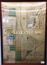
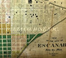
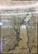
1903 map of Escanaba |
Catalog Number |
A-2016.24 |
Object Name |
Map |
Creator |
Brotherton, D.A. |
Scope & Content |
One framed 1903 map of Escanaba by D.A. Brotherton. Map is 35.5" x 50 (including frame). There is an insert map of Delta County with section numbers. The Escanaba map has a white background with four additional colors marking various additions to the original plat. Also included are ward numbers, railroad tracks, boundary lines, police and fire alarm boxes, water works installations, block and lot numbers, and house numbering system for east and west ( Wells Avenue) and north and south streets (Jennie Street). Extensive detail is given to the C & NW buildings, docks and railyards. |
Collection |
Map Collection |
Search Terms |
Chicago & North Western Railroad Escanaba Harbor Escanaba Ore Docks Escanaba Streets Escanaba, MI Escanaba City Maps |
Subjects |
Docks Maps Railroad yards Railroads Water works |
People |
Brotherton, D. A. |