

Archive Record
Images
Metadata
Title |
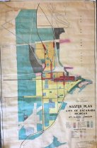
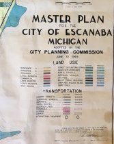
City of Escanaba, Master Plan map |
Catalog Number |
A-2020.Fic.181 |
Object Name |
Map |
Pub Date |
1949 |
Scope & Content |
Shows a Master Plan for land use in the City of Escanaba adopted by the Planning Commission in June, of 1949. Map shows various types of land use from residential, to commercial and industrial. Transportation systems are deliniated as are public use areas, such as schools, utilities, parks etc. There is also some emphasis on plantings and forest areas. The map was drawn by K.M. Oshe and accepted by O. Thatcher, secretary of the Escanaba Planning Commission. |
Map Language |
English |
Collection |
Map Collection |
Search Terms |
Escanaba City Government Escanaba City Maps |
Subjects |
Land use Maps Planning drawings Planning, City |
People |
Oshe, K. M. |