

Archive Record
Images
Metadata
Title |
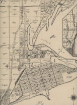
Map of City of Gladstone, Mich. 1929 |
Catalog Number |
A-2023.42.01 |
Object Name |
Map |
Creator |
Goddard, Leslie |
Scope & Content |
A 1929 map of the City of Gladstone showing streets, industrial locations and property owners for some of the land adjacent to the city limits. The location of the Northwestern Cooperage and Cleveland Cliffs Iron Company, the Webster L. Marble Athletic Field, and the McGillis and Gibbs Lumber business are all seen. Ward lines are drawn in showing each ward. The location of the Gladstone Bluff is also indicated. An inset map shows the location of Gladstone. This is a very nicely done piece of map making by Engineer Leslie D. Goddard. |
Collection |
Archives |
Search Terms |
Gladstone Maps |
Subjects |
Cities & towns Maps Streets |
People |
Goddard, Leslie D. |