

Archive Record
Images
Metadata
Title |
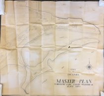
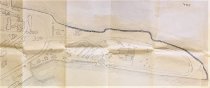
City of Escanaba Master Plan, Ludington Park, Yacht Harbor& Beach Area |
Catalog Number |
A-2020.34.01 |
Object Name |
Map |
Scope & Content |
Drawn by Bob Richards in 1945 this shows the Ludington Park area from Sand Point to the softfball field. Details are a projection of the descriptions in the city's master plan of the time. Harbor details are comparable to the late 1950s with some major exceptions. There is no Harbor Master's building, no boat launch facility. Aronson Island is undeveloped, with the plan calling for a "group picnic" area. |
Collection |
Archives |
Search Terms |
Escanaba City Government Escanaba City Maps Escanaba Harbor Escanaba Yacht Harbor Ludington Park, Escanaba Sand Point Lighthouse (and Sand Point) |
Subjects |
Beaches City planning City planning drawings Harbors Parks Plans |
People |
Richards, Robert |